Charter Sites Offered by Freedom Scuba USA
We run the largest Charter Boat on the US side of the St. Lawrence Seaway.
SS Keystorm
SOS does not recommend penetration of this wreck.
Dive lights are highly recommended for each diver.
Novice to Advanced level Divers.
Some fishing lines may be present, exercise caution.
Visibility is up to 15-25 ft. on a good day.
Large fish are usually present, especially at night.
Wreck is in U.S. waters under U.S. Coast Guard and State of New York jurisdiction.
Divers should pay very close attention to their depth and limitations of air supply.
The wreck of the S.S. Keystorm is located in the St. Lawrence River in U.S. waters, 1 mile Northwest of Oak Island and can be reached by boat. Charters are recommended from either Browns Bay Provincial Park dock (near Mallorytown, Ontario on the 1000 Islands Parkway on Canadian side approximately 3 nautical miles Northwest of site) or from Brockville Marinas. The site is at N 44 25.8′ Latitude, W 75 49.3′ Longitude. A mooring buoy of coloured jugs is usually present. Parks, camping sites, motels are available in the Mallorytown area. Ref. Canadian Hydrographical Services chart #1418.
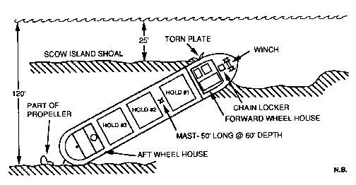
The S.S. Keystorm was built in Great Britain in 1909-1910 for the Keystorm Transportation Co. in Montreal. She was a cargo steamer, 258 feet long with a 42.5 foot beam and a displacement of 2300 ton. She had two boilers and a triple expansion steam engine with 16″, 26″, and 44″ diameter cylinders X 36″ stroke placed aft. The after house contained the galley, crew’s men, dining room and quarters for chief, oilers, firemen and second engineer. The rest of the crew including the captain’s cabin were in the forward quarters. The pilot house was arranged particularly for canal service.
On October 12, 1912 while bound from Ashlabula, Ohio to Montreal with a load of coal, she struck Scow Island shoal in fog near Alexandria Bay N.Y. The pumps were put in operation immediately but it became evident that the ship was doomed. Five hours later the Keystorm sank stern first and rolled over onto her starboard side going down. While her cargo of coal was salvaged, several attempts to raise the ship using steel pontoons failed. Formal hearings and investigation revealed that both Master and Mate were negligent in navigation and command of the vessel causing its loss.
The A.E. Vickery
Ship Type: Wooden Schooner
Lifespan: Built 1861, Sunk 1889
Length: 136ft
Depths: 60ft - 115ft
Location: Rock Island Shoal, St. Lawrence River, New York side
GPS: N44 16.820 W076 01.183
The A.E. Vickery was built in 1861 and launched in July of that year at Three Mile Bay in New York. Originally named as the J.B. Penfield, she was renamed in February 1884 as the A.E. Vickery. A three masted wooden schooner, she was carrying a load of corn en-route to Wisers Distillery in Prescott, Ontario, when she struck the shoals in the narrows on August 17, 1889. There was no loss of life in the sinking.
The wreck itself lies on a ledge adjacent to Rock Island Shoal. The site is buoyed with a line that takes you down over the ledge to the port bow of the wreck, which lies at approximately 60 ft in depth. The wreck continues down the ledge and reaches a depth of about 115 ft at it's stern. There is a fair bit of current as the wreck site is in a narrow portion of the river. Because the wreck lies at an angle on the shoal, on the wreck itself, the current is much less as the deck is somewhat sheltered. As well, the wreck can be penetrated through a number of cargo hatches in the deck. Once inside, current is pretty well non-existent.
At the bow of the wreck is the ship's windlass. As well, the rudder appears to be more or less intact. Two section of masts lie to the starboard side of the wreck.

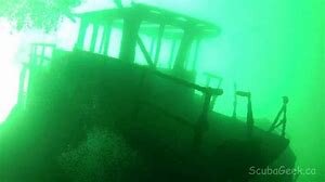

The America

The America, as it is most commonly referred to, was actually named the "American". It was used as a blasting barge to make sure parts of the St. Lawrence River was clear for ships. The wreck site is located just across the shipping channel from Jordstat Castle and Dark Island, just east of Mallorytown Landing. The wreck lies on the US side of the river. Canadian boats going to this wreck must check in with US customs first.
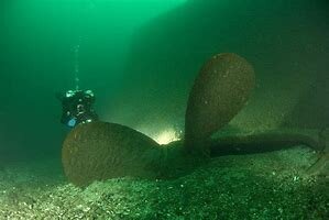
The America came to a sudden end as a result of an accidental explosion in 1932, The ship sank in an overturned position near some shoals, but currently rests in about 75 to 80 feet of water. Care must be given when diving the site. The mooring buoy is in shallower water, but the strong current must be considered when traversing the guideline that runs from the large anchor (which actually wasn't from the America) at the mooring site, which goes over some shoals and down the slope to the wreck. Underneath the wreck lies a heavy layer of oily silt, so care must be taken not to touch or drop down into the silt, lest your gear becomes coated with black oil.
The underside of the wreck can be easily penetrated, with easy access to the outside from both sides. On the wreck itself, the current is very manageable. However, it can be a struggle getting to the bow of the wreck. If you choose, you can then ascend to the top of the wreck (the bottom of the ship since it is overturned) and fly the keel back to the stern. You will see the two large props protuding from the stern. Be sure to grab the line as you reach the stern or you may be in for a ride into the shipping channel.
Ship Type: Steel Drill Barge
Sunk June 20, 1932
Length: 92 ft
Depths: 80 ft
Location: Across the shipping channel from Jordstat Castle and Dark Island, St. Lawrence River, New York side
GPS: N44 27.070 W075 49.110
Henry C. Daryaw

The Henry C. Daryaw was a 220 ft long steel freighter that sank in 1941 when she ran upon a shoal between American and Canadian Channels. The navigator did not see the shoal in a deep fog and Daryaw ran into it striking her bow. The Daryaw flipped upside down while sinking and landed right next to the channel wall with the deepest part at 90ft.
6 miles west of Brockville, Ontario and approximately 1/4 mile from shore
~ GPS Shipwreck Location ~
Latitude: 44° 31' 34.0212" N Longitude: -75° 45' 45.2412" W